|
Hiking Log
Hiking Locations
Data Analyses
Pictures
Recent Changes
|
2018 | |
Up to current log.
|
| |
2017 final report: 307 miles hiked, 113 030 feet ascent. Average hiking speed 1.84mph. 44 total hikes, 9 overnights.
|
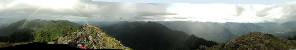
20171231 8.5mi 1090m | Mt Washington (new trail) |
...
pikae pictures
|
20171226 9.1mi 925m | Squak Mountain |
Margarets Way, Debbies Viewpoint, West Peak Trail, Central Peak, Central Peak Trail, Bullit Fireplace Trail |
...
pikae pictures
|
20171223 6.0mi 650m | Commonwealth Basin, Red Mountain approach |
Lots of snowshoeing.
...
pikae pictures
|
20171209 6.7mi 910m | Bandera Mountain |
Interesting temperature inversion west of the cascades right now. It was near 20F in the parking lot at 2000ft and almost 60F atop Bandera. Surface ice for most of the beginning of the hike, giving way to snow. While the snow was still a bit crispy on the top, it was very soft underneath, but I got back down off Bandera before the sun warmed things enough to produce wet avalanches.
One of the bindings on my spikes bent open at some point, presumably before today, but finally detached and managed to catch on the opposite foot... so I went crashing to the ground. Stopped for about 20min to fix it using very advanced tools (two rocks).
...
pikae pictures
|
20171205 11.7mi 1000m | Snoqualmie Point, Grand Prospect, East Peak |
Yay snow!
...
pikae pictures
|
20171128 9.6mi 1010m | Teneriffe Road, approach on Blowdown Mountain |
New boots, continuing to break in / arrange all the components of the new boots.
Rain, solid, and increasing near the end (as expected).
...
|
20171118 6.1mi 1100m | Old Mt Si trail |
New boots.
...
pikae pictures
|
20171114 6.0mi 860m | Tiger Mountain |
Cable Line, WT3, WT2, K3, West Tigger Railroad Grade, Section Line, Talus Rocks, Nook.
...
pikae pictures
|
20171021 10.85mi 1325m | Thompson Lake |
Weekend forecast of considerable rain, so I decided to try a new place. Snow encountered around 3500ft elevation together with a significant increase in wind and gusts. Nose hairs were getting a bit crispy, which was unexpected in the 50F forecast. I was only in full rain gear at that point, and had to use my spikes and add the upper light thermal layer. Wind on the south side of the ridge approach to the lake saddle was reduced, but there was steady wind in the lake bowl and on the ridge itself. 4--8" of snow in the bowl made walking difficult; the spikes were balling, leading to more snow-on-snow skiing than actual walking. With the steepness of the descent, poles were warranted.
I reached the primary talus field, which is the first that the lake even becomes visible, and decided to take a few pictures and depart. Another hour would have been needed to descend the rocks and return (mostly invisible trail), and the unexpected winds above the lake weren't very inviting. Moreover, rain was expected to increase steadily with an additional half inch arriving in the next few hours.
...
pikae pictures
|
20171014 8.2mi 1020m | Rattlesnake Ledge to East Peak |
...
pikae pictures
|
20170923–0927 65.3mi 5615m | Pacific Crest Trail Washington Section J: Snoqualmie Pass to Tunnel Creek Trailhead |
See daily comments below.
pikae pictures
pikae pictures
pikae pictures
|
20170927 7.5mi 560m | Pacific Crest Trail Washington Section J: Glacier Lake to Tunnel Creek Trailhead |
...
|
20170926 15.0mi 1350m | Pacific Crest Trail Washington Section J: Deep Lake to Glacier Lake |
...
pikae pictures
|
20170925 7.2mi 660m | Pacific Crest Trail Washington Section J: Waptus River to Deep Lake |
...
pikae pictures
|
20170924 18.1mi 1235m | Pacific Crest Trail Washington Section J: Spectacle Lake to Waptus River |
...
|
20170923 17.5mi 1810m | Pacific Crest Trail Washington Section J: Snoqualmie Pass to Spectacle Lake |
Day One of the five-day jaunt north along the PCT saw a great deal of driving, roughly two hours to Stevens Pass to drop off Brian's car, then another two hours taking Chirpy to Snoqualmie Pass. Perhaps we should have planned to pay for a ride once reaching Stevens, but bumming a two-hour ride on a Wednesday would probably have meant a lot of highway walking with a sign. I've often thought to get in more hikes to the north, but many of them along Highway 2 are sufficiently close to the pass as to be impassable during most of the winter and spring months. With Snoqualmie, most are accessible ten months of the year and only an hour away.
Despite the long drive, we managed an early enough start, around 8AM, and found quite a few groups were heading for the Kendall Katwalk area. We decided to cut off a mile and use the Commonwealth Basin trail, which, while a bit steeper, allowed us to get to the PCT and bypass most of the crowds. We were hiking faster than most, though Brian was a bit overloaded, but we still passed a few groups. One group "refused" to let us pass (meaning they recognized we were there but weren't going to stop).
Snow appeared in the shadow side of Kendall Peak near the Katwalk, and there were pockets heading to the first lake. A cool breeze rose from the valley to the north, so the stop at the lake required a jacket and hat, and was to be the first official break of many. By this point, indeed in the first 45 minutes, I had a blister on my right heel; apparently a piece of tape had rolled or something else had gone awry.
Past the lake, the remaining day hikers dwindled, though there were some trail runners. By Alaska Mountain, the sun was out and starting to bake on the south slopes, but, fortunately, there were still some trees as the trail wiggled around. The trail along south Huckleberry Mountain was very nice, distinct rocky dropoffs, and the wind was sufficient to stay cool.
Snow appeared again in the bowl leading northeast, and much of the way southeast along Four Brothers to the saddle. Spikes were in hand but on-and-off. We passed a group of three heading for the Canadian end of the PCT that had aborted Section J last week due to the heavy rains. A few more miles down through the forest left us at the Spectacle Lake turn-off. Though I was certain I had seen one group at the lake, we apparently had it to ourselves for the evening.
The sun and water were warm enough for a staged bath (for me, in any case). I spent a good deal of time getting a lead line in a high enough branch for a bear bag; I must say that the PNW coniferous trees really don't have branches that support much weight. Sadly, after eating and packing up everything, I tried to fit both Brian's and my food bag on there and the line came down, so we were out in the dark with headlamps trying to get it back up. Managed, eventually.
Brian and I had decided to position our tents with the doors facing, and near to each other, so we stayed warm in our sleeping bags while discussing tomorrow's route, potential water stops, and suchmuch.
Overnight was relatively warm, not dropping much below 50F until well into the morning. Some condensation. I used my new, low-profile ear plugs a bit. Didn't need a foot warmer. Was still awake a lot.
pikae pictures
|
20170909 11.1mi 1090m | Hall Point, Mt Washington |
Practice hike, 35lb pack with all the multiday gear, just a bit light on food.
...
|
20170825–26 37.9mi 2820m | PCT WA K, Stevens Pass to Pear Lake |
Intended as a three-day hike, the return Saturday mid-afternoon found too many weekend warriors at Lake Valhalla. Finding a spot near the lake with water access would have been difficult, and a restaurant was calling, so the decision was made to finish the last 6mi. It may have been the wrong decision because the last 2mi destroyed my feet and hiking buddy Brian was hobbling.
...
pikae pictures
pikae pictures
|
20170815 7.2mi, 1500m | Dirtybox Peak, Mailbox Peak Spur Trail and Old Trail |
...
pikae pictures
|
20170729 10.2mi, 1450m | Silver Peak, Abiel Peak, Tinkham Peak, Tinkham East, Mirror Lake |
...
pikae pictures
|
20170716 0mi | (aborted) |
Farthest and furthest I've made it toward a hike before turning around, but after getting 10mi down the road the left rear squeak had advanced to a full rear vibration above 50mph with no alleviation expected. I checked a few things to find nothing obviously wrong, got back on the highway, then turned around at the next exit. My plan had me driving 110mi on the highway plus another 45--60min on a forest service road, and it seemed unwise to do so when the vibration could well have started causing secondary damage to components.
Weather was expected to be only slightly above 50F at Snoqualmie Pass today and mostly cloudy in the morning. I was looking forward to a great reprieve before what will doubtless be three or four weeks of heat wave. Leading into August, that does not paint a good picture for hiking in the next eight weeks.
Needless to say, Spike and Kage were terribly sad that they were unable to play in the rocks.
|
20170704 10.7mi, 1270m | Hall Pt, Mid Mountain, Hall Peak, Mt Washington |
Made the Class 3 approach to Hall Peak. While there were some clouds obscuring the view at times, it was clear and bright enough to find a route along the ridge to make the summit. My previous attempt was thwarted by drizzle and lack of visibility, though, had I known about one bypass that I executed this time, I probably could have made it.
...
pikae pictures
|
20170624–25 18mi, 1860m | Talapus, Olallie, Tuscohatchie, Melakwa Lakes, Kaleetan approach |
It was unfortunately warm and there were too many people roaming around.
...
pikae pictures
|
20170617 8.7mi, 1020m | Lake Serene, Bridal Veil Falls |
...
pikae pictures
|
20170610 13.5mi, 1765m | Mt Teneriffe, Dixie Peak, Blowdown Mountain |
Yay it snowed, twice!
...
pikae pictures
|
20170603–04 28.3mi, 2075m | Suiattle River, approach to Miner's Ridge Lookout |
...
pikae pictures
pikae pictures
|
20170513 6.5mi, 1130m | Old Mt Si trail, Boulder Garden Loop |
...
pikae pictures
|
20170506–7 12.1mi, 600m | Lower Big Quilcene River |
(Camp Jolly 10.1mi RT 425m ascent 167m descent, plus a visit to the Upper Big Quilcene River trailhead estimated 1mi+)
...
pikae pictures
pikae pictures
pikae pictures
|
20170422 5.5mi, 736m | Silver Star trail, Yacolt Burn State Forest |
...
|
20170408–9 9.25mi, 670m | Ancient Lakes |
...
pikae pictures
|
20170402 7mi, 425m | Lime Kiln Trail |
...
pikae pictures
|
20170325 14.5mi, 1385m | Squak Mountain |
...
pikae pictures
|
20170311 6.5mi, 940m | Zig Zag |
This was probably the most technically challenging hike in the last several months. While nothing on this trail is particularly dangerous, nor is one hiking at the top of some ice-covered avalanche beast, the recent snow and higher temperatures meant that there was no footing anywhere throughout the hike. The first half of the trail is steep in places, but 6--12" of fresh snow from the past few days had fallen as Pacific Northwest concrete; spikes provided little to no traction as the snow merely compressed under foot. Multi-stepping helped in some places, but I had to break out the trekking poles, which I rarely do.
Upon reaching the upper road, I put on the snowshoes, which I would wear almost the whole way back later. I was already exhausted but trudged on; indeed, the stretches east and west felt like they took less time than I was expecting. Nevertheless, each step was met with several inches of drop, raising the actual ascent considerably. By the middle of the westward section, the snow had started to crust, but there was rarely sufficient support. Even at the top I fell through 99 steps out of 100. Needless to say, it was a very, very slow journey: It took at least twice as long as some previous hikes to the 'summit'.
The way down was not much better. My own tracks collapsed in some places, or the snowshoes were sliding forward underneath the snow on the downhills. Things improved a bit on the lower portions of the upper road, and I kept the snowshoes in place all the way down the zigs; they had better traction than the spikes, and though there were some roots or rocks, careful footing prevented punctures. I fell down once (expectedly) --- but then again I expected to fall with each step --- and slipped a few more times. I managed to get low enough and went back to boots plus one pole for the last few snow piles and last quarter mile of the descent.
I was 30min late leaving in the morning, but fortunately the rain arrived a bit late as well (maybe 35min, haha), so I was still able to get a few pictures of the valley before everything clouded over. It started raining shortly after my summit arrival, as wet flakes above 4000ft, and did not stop raining except for a few five minute breaks.
On the upper stretches, there were a few spots that could have managed a loose-wet avalanche, particularly with the arriving rain. While I was not greatly concern, I did pay particular attention to those few spots, but basically just played the "hope it doesn't choose now" game. A slide would have meant a significant run-out in places, or banging up against trees in others, so... shrug.
All in all, this was a very challenging hike, both mentally and physically. Last week, wading through hip-deep, fresh powder and navigating in a 25mph/25F snow storm, was simple by comparison. The footing issues and extra time requirements were such that I could have turned around after the first 30min and stuck to lower trails, taken pictures of the river and low falls, gone and showshoed the Iron Horse SP trail (old railroad grade, so flat as flat can be). I just kept trudging, taking breathers, and figured I'd deal with all the descent troubles when I got to that point. It ultimately worked.
pikae pictures
|
20170304 3.7mi, 500m | Artist Point |
...
pikae pictures
|
20170218 8.3mi, 720m | Grand Prospect, Snoqualmie Point |
...
pikae pictures
|
20170128 3.0mi, 750m | Guye Peak |
Notable snowshoe and ice axe work getting to Guye Peak. The hardest section being near the start of the trail where 3ft of powder was on top of an ice layer and required wading/swimming up a 55--60deg slope; it probably took 30min to ascend 200ft. Overall the trail is 1650ft/mi one way, so it's steep in the summer; add on all the lost ascent due to the snow, and it becomes much "steeper".
The weather was weird, with snow levels rising to 8kft overnight, surface temperature predictions rising to 45F during the day, but winds aloft holding near 40F. There was a fog layer holding in close to the mountains below the 4kft level, so temperatures stayed depressed. Atop the peak was very warm as the sun had pushed through the clouds, and was probably above 40F. Nice pictures from the summit as clouds were above 20kft.
Pikae
...
pikae pictures
|
20170114 11.9mi, 1360m | Tigger |
Cable Line, WT3, WT2, WT1, Bootpath Trail, Paw Print rest area, 15-Mile Railroad Grade, Hidden Valley, Larry's Crossing, Poo Poo Point, West Tiger Railroad grade, Cable Line (descent)
I was expecting to be on call this weekend, but the team schedule changed mid-week and I was able to fit in a quick jaunt. Being that I was not fully mentally prepared, however, it seemed appropriate to stretch my legs a bit, stay off of the snowshoes, and let various injured parts of the body heal while I was hiking.
...
pikae pictures
|
20170107 10.4mi, 1900m | Hillary Montes |
Hillary Montes :]
Mt Wa new trail, Great Wall Trail, Mt Wa. I had intended to ascend Change Peak, but conditions altered my plan, as shall be noted.
The new system should handle this issue, but the "1900m ascent" recorded in the track is likely to be a bit in error. While there are no significant data issues, there are several miles where a number of small altitude variations are visible. This is common for GPS receivers in phones, but I have not typically seen this behavior for a standalone receiver. Given the drifting snow encountered, there were a number of small rises to consider, but the overall ascent should not be nearly double the elevation change. I have already developed the necessary handlers for this situation, but they are not yet cleaned up enough for use, so I'll report the 1900m at this time. The "true" value is likely closer to 1500m.
...
|
2016 | | Hiking log from 2016
|
2015 | | Hiking log from 2015
|
2014 | | Hiking log from 2014
|
2013 and earlier | | Hiking log from 2013 and earlier
|
|